
Fisheries, Wildlife and Habitat
Kasilof River Personal and Commercial Use Fishery
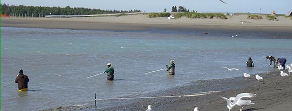
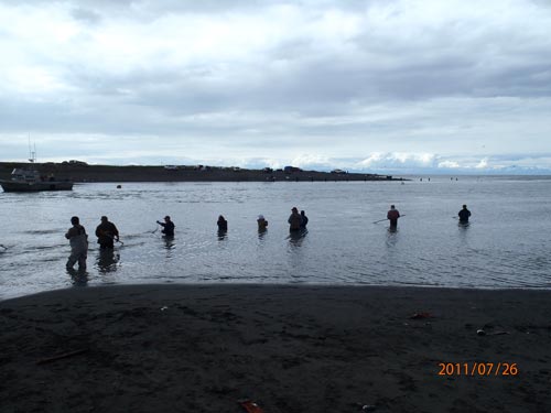
In 1981, the Alaska Board of Fisheries (BOF) created a personal use dip net fishery around the mouth of the Kasilof River. In 1982, the BOF also created the personal use gillnet fishery in the marine waters adjacent to the mouth. These fisheries, managed by the Alaska Department of Fish and Game (ADF&G), are only available to Alaskan residents and were initiated as an alternative to replace subsistence fishing. In recent years these fisheries have become increasingly popular, due to increased population and recent economic instability. These fisheries provide thousands of Alaskans an economical way to stock their freezers for the coming winter months, while enjoying the social benefits that have become an integral part of the fisheries.
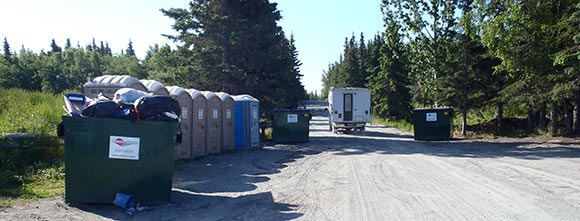
 All participants of the Upper Cook Inlet personal use fisheries, including the Kasilof, are required to obtain a permit (or be a member of a household with a permit). Completed permits must be returned to ADF&G following each fishing season. The total limit for the personal use fisheries is 25 salmon for the head of the household and 10 salmon for each additional household member. Management of the set gillnet fishery is the responsibility of the ADF&G Commercial Fisheries Division, and management of the dip net fishery is the responsibility of the ADF&G Sport Fish Division. Both fisheries open and close by regulation and in-season management is only required if the fish counts and biological escapement goals cannot be met or projected.
Sockeye (red) salmon is the primary harvest for both of the personal use fisheries, with a limited number of Chinook (King) salmon taken from the personal set gillnet fishery. The peak Sockeye runs typically occurs around mid-July. A large scale commercial set gillnet fishery (including DMLW, SCRO issued set net leases) are present adjacent to the shoreline beginning approximately one mile north and south of the river mouth. The area is also an extensively used harvest area for the commercial drift gillnet fleet, including the existence of a significant number (over 120) of commercially used mooring sites (buoys) beginning at the river mouth, and extending about 2 miles upstream. The Kasilof River and adjacent state uplands and beaches are also very popular for other opportunities such as boating, hunting, beachcombing, wildlife viewing, picnicking and camping.
ADF&G Kasilof River Personal Use Salmon FisheryWildlife and Habitat
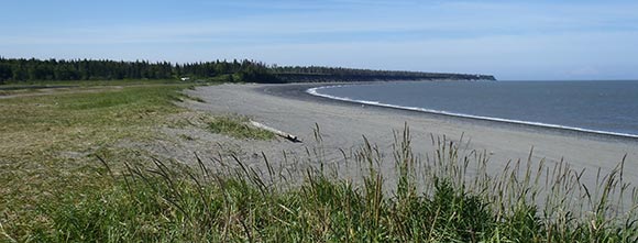
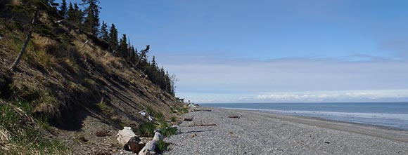
The Kasilof River and adjacent uplands form an interdependent ecological system rich in important land, water and wildlife resources that Alaskans have grown to appreciate and depend upon. Most of the upland areas adjacent to the Lower Kasilof River are relatively low-lying, located within a designated flood zone. 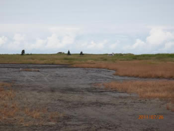 These areas have been affected by damaging flood events as recently as 1995 and 2002. The lowlands of the lower river extend towards the mouth, where wide and exposed mud flats are surrounded by flat marshy land. The lowlands support patches of semi-open black spruce and muskeg, as well as shrub and grass lands. These factors, combined with the highly erodible bluffs of the coastline, make development in the area somewhat difficult. Directly adjacent to the river mouth on both the north and south uplands, sandy beaches exist on the ocean forefront, then salt tolerant plant species (mainly grasses) are found in the slightly higher sandy benches (i.e.: the dunes). An extensive area of wetlands is also found on the southern side of the river mouth. The dunes including the grasses form a natural barrier and aid in protection of the adjacent wetlands and flood plain(s). These wetland areas provide natural water storage and habitat for various species and perform important water quality functions. The beach and dune areas are also heavily used by campers and fisherman during the summer season.
The grasslands and adjacent wetland areas directly adjacent to the mouth support a variety of species, particularly in the southern area of the mouth (unit KS). The area supports duck and geese spring (April - May) and fall (August - November) concentrations, seabird and shorebird nesting areas, and trumpeter swan general distributions. The wetland areas also support nearby known moose wintering and rutting concentrations and calving concentration areas. The Kasilof River and adjacent Tustemena Lake are extremely important systems which support both resident and anadromous fish populations, including habitat for Chinook (King) Salmon, Sockeye (Red) Salmon, Coho (Silver) Salmon and Pink (Humpy) Salmon during their sensitive life cycles (i.e.: spawning and rearing). The system is also home to Dolly Varden Char and Steelhead species.
The Kasilof River area is located within ADF&G Game Management Unit 15. Subunit 15C (the Lower Kenai Controlled Use Area) does not allow anyone using a motorized vehicle (except an aircraft or boat) for moose hunting, including the transportation of moose hunters, their hunting gear, and/or parts of moose from September 11-14 and September 17-20. However, this does not apply to the use of motorized vehicle on a state or borough maintained highway, the graveled portions of Oilwell, Brody and Tustumena Lake Roads, or driveways used for direct access to a primary residence or business per Alaska Hunting Regulations 2010-2011 pg. 76.